
| HOME PAGE | |
| CONSULTANCY | |
| PUBLICATIONS | |
| > | TOPICAL - Slapton |
| Site Map |
e-mail enquiries to:
info@coastalresearch.co.uk
or write to:
Coastal Research, Tamarisks, Waresfoot Drive, Crediton, Devon, EX17 2DG, UK
or telephone:
+44 (0) 7814 101665
This page was updated on 6th March 2026.
All lakes are transient; they eventually fill up with sediment. They're often described as wide places in rivers.

In the case of Slapton Ley it's easier to think of the Higher Ley (North) and Lower Ley (South) as two separate lakes, although now linked by an allegedly man-made channel near Slapton Bridge. The drainage basin area of the whole of Slapton Ley is 46 km2; that of the Higher ley is about four times the area of that feeding the Lower Ley. That means the fluvial inputs, water and sediment, are proportionately larger for the Higher Ley; which explains why it has been filling up with sediment more quickly.
Before they became freshwater lakes they were estuaries, and possibly lagoons before that. It is clear that the slow progression of the Shingle Ridge moving inland, as sea level rose during the Flandrian Transgression, eventually blocked the valleys of The Gara river flowing into the Higher Ley, and the smaller stream valleys of the Lower Ley. That damming took many hundreds, probably thousands, of years to evolve. Various studies of the origins of the Ley have found evidence of estuarine muds in the lake beds. It is considered that today's shingle ridge was initially two shingle spits with openings to the sea at Strete Gate and Torcross. We know that both lakes now flow South to the corner at Torcross where a culvert (tunnel) allows the excess freshwater to drain to the sea. The man-made weir, now covered with a substantial metal grid, keeps the lakes at a near constant level. That level is approximately 4 metres higher than Mean Sea Level, so today sea water ingress is eliminated. Mean Sea level is the basis of Ordnance Datum, used by the Ordnance Survey of Great Britain as zero for contours and bench marks. Ordnance Datum is applicable to the whole of Great Britain and should not be confused with Chart Datum which is defined as the Lowest Astronomical Tide level for a particular locality. In the area of Start Bay Chart Datum is approximately 3 metres lower than Mean Sea Level.


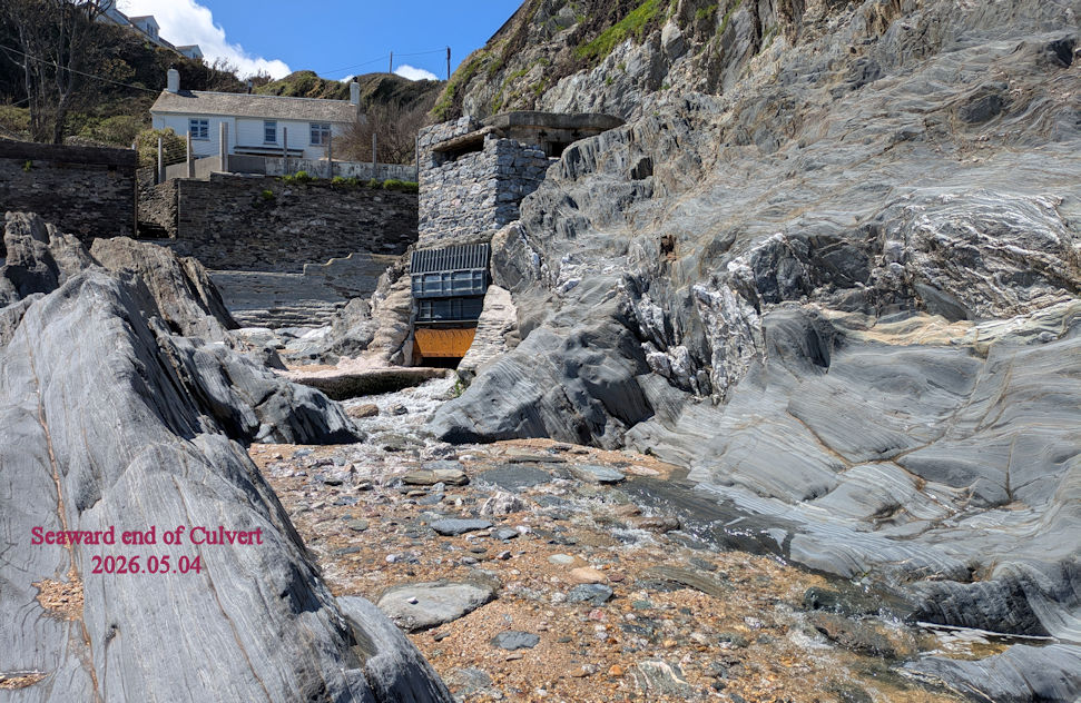
The Culvert to the Sea, allegedly cut by Welsh miners in the latter part of the 19th Century, was routed through the Meadfoot Slates. Solid bedrock rather than mobile shingle. It was a wise decision.
An approaching barrier beach will form a complete closure of a very small valley with negligible fluvial inputs. This can be seen as just a shingle or sand beach; scores of examples are found around South West England. Small volumes of freshwater will just percolate through the shingle or sand and can be seen at Low Water. Interstitial spaces in the shingle or sand eventually become blocked with fine particles although it will be a considerable time before that causes a small lake to form, and only if land behind is flat and low lying. Clay particles (less than 2 microns) are the most effective at forming a watertight seal which can then mean a lake will become a long term feature.
Where an advancing sedimentary feature attempts to block a large valley then a spit will form so that fluvial inputs from the valley are still able to drain seaward through a gap. This was almost certainly the case at Strete Gate. Estuaries develop behind a spit. Their characteristics are determined by the tidal range of the area, together with the fluvial inputs. Examples are found around the South West, such as The Teign Estuary at Teignmouth.
The date for the man-made channel being cut between the Higher and Lower leys is not known. That could have been when the Strete Gate channel into the sea was no longer necessary and the shingle ridge closed the gap naturally. It would also be an indicator of the date when year round human transport along the Shingle Ridge became viable. A date of 1856 is given for when a turnpike, or toll, was set up. Possibly the approximate date when the drainage channel at Torcross was changed to a culvert.

The effects of occupation by the United States military in 1943 and 1944 does not appear to have any records. There is some evidence of bomb craters in the Ley. As for the Ley in recent times, it was declared a Site of Special Scientific Interest (SSSI) in 1952, and National Nature Reserve (NNR) in 1993. It has proved a popular attraction for wildlife observation and field studies. Prior to that it was used for wildfowl shooting. Probably the most significant influence on nature appreciation was the establishment of the Field Studies Council (FSC) Start Bay Centre in 1969. The Ley is managed by the FSC. It has been owned by the Whitley Trust, now renamed Wild Planet Trust.
The implications of a storm activated breach in the Shingle Ridge, and loss of freshwater to the sea, do not appear to have been contemplated from nature or economic perspectives.