
| HOME PAGE | |
| CONSULTANCY | |
| PUBLICATIONS | |
| > | TOPICAL - Slapton |
| Site Map |
e-mail enquiries to:
info@coastalresearch.co.uk
or write to:
Coastal Research, Tamarisks, Waresfoot Drive, Crediton, Devon, EX17 2DG, UK
or telephone:
+44 (0) 7814 101665
This page was updated on 14h July 2026.
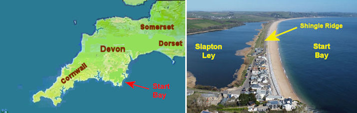
Slapton Shingle Ridge, South Devon, England
Diary Updates for Slapton/Torcross
Heavy weather at the end of January and early February 2026 caused considerable damage to the shingle ridge near Torcross. The A379 road along the top of the ridge was breached and there was the risk that further wave action would erode the rest of the shingle and cause the Freshwater Ley to drain seaward at the next Low Water. Many buildings in Torcross were severely battered and flooded with sea water.
Placing on Record, letter to BBC Spotlight
Some explanation of the wind and waves
Barometric Pressure had been below 980 mb several times during the gales. The Low Pressure systems had generated the strong Easterly and South Easterly winds. South Devon is a macrotidal environment, tidal range in excess of 4 metres. The Full Moon on 1st February resulted in Spring tidal ranges, greater than 4 metres, raising sea level during the strong gales. That together with the Low Barometric Pressure meant higher High Waters morning and evening. South Devon gets severe gales every winter. When they occur at Neap Tides, tidal ranges can be as low as 2 metres. Those conditions can still produce rough seas but wave damage to the coastline is much less than at Springs.
The random nature of weather systems means that people who live near vulnerable coastlines may experience several years before repeat Storm Events cause havoc during Spring tides. At Slapton records show that severe storms during Spring tides affect the area every few years. Advice to retirees and holiday home enthusiasts is never buy a property near the coastline based upon a viewing on a sunny day in June. Visit the property during a winter gale!
Climate change and sea level rise are phrases dropped into speeches by all manner of politicians and public servants. Numbers rarely mentioned, phrases just uttered for effect. We know that there has been some alteration in our weather patterns recently but sea level rise is measured in the low millimetres each year. As it has been for centuries following the last Ice Age.
So what is the real reason for the damage at coastlines? Predominantly it is due to human interference.
In the case of the Slapton Shingle Ridge we know that there have been several events in the last hundred and thirty years which have led to the current threats to its survival, and that of Slapton Ley. Various records state that somewhere in the region of half a million tonnes of shingle were dredged from the nearshore zone near Hallsands, and taken to Devonport Dockyard to make concrete to build the quays. That was in the late 19th Century. One horrific night in 1917 so much shingle had been removed from the nearshore zone at Hallsands that the beach was lowered and wave damage caused loss of nearly thirty houses.
The reduction of beach sediments had been noticed by residents at Hallsands fishing village and by local spokespeople. It was reported to government officials in the early 20th Century, but to no avail, and in 1917 the village was destroyed.
Another event was in 1943/1944 when the U.S. Army occupied a wide land area around Slapton. Farmers and residents were evacuated to other areas of South Devon.
The American Army used Slapton beach for practice landings as a rehearsal for D-Day landings. Unfortunately, a tragedy occurred and many military lives were lost. The shingle ridge road was probably stiffened at that time with more hardcore and tarmac. Prior to that the road was certainly in place but had been used by local people with horses and carts, then motor vehicles. Dates for increased stiffening of the A379 road are unclear but the important consideration is that shingle ridges must be allowed to move during storm events. This movement is often described as Roll-Over, whereby storm waves throw some pebbles beyond the ridge summit and they remain on the landward side of the ridge permanently. Over many years this accumulation means the shingle ridge moves slowly inland.
The Slapton Shingle Ridge has been migrating onshore naturally for the last eight or ten thousand years, following melting of the last Ice Age. That's how Slapton Ley was created.
Beach levels have been changing in Start Bay for many years, not just following the Hallsands dredging. When beach levels are lowered naturally it means that the beach sediment volume has been moved Longshore or Cross-Shore to the nearshore zone. Beach levels can also be lowered when highly reflective structures are put in place. This results from scour removing shingle towards the Nearshore Zone.
Winter gales with their Destructive Waves cause shingle to be pulled back into the Nearshore Zone, below the Low Water Mark. If winter gales are of short period, common with Easterlies, they are steeper and tend to be more destructive. The constructive waves of the Summer months, particularly if they are of a longer period, can rebuild the beach. This is Cross-Shore movement. Shingle ridges like Slapton, Chesil Beach in Dorset, Loe Bar in Cornwall, often reach their maximum height about September of each year. Any stiffening of the ridge by roads or man-made structures restricts the ability of the ridge to respond to natural processes such as roll-over, the process by which sedimentary ridges migrate slowly inland.
Beach volume changes are a combination of both Longshore and Cross-Shore processes . With four to sixteen wave cycles a minute, a great deal of movement can take place each day. It all depends on weather, which controls wave energy, wave period and wave direction. Weather, unlike tides, is notoriously difficult to predict.
Greater problems occur when coastal defence schemes place reflective structures on beaches attempting to convince local people that the structures will save their properties. Concrete, steel piling and even rock armouring all increase reflection of wave energy and lead to scour taking shingle into the Nearshore Zone. The engineers who build these structures fail to understand that they are building on a substrate of shingle and other sediments which are mobile. Given time or excessive energy the substrate moves. Recent video evidence clearly shows the consequences of reflected waves at Torcross.
The reason for asking the local BBC to keep up their news monitoring during adverse weather is that reflective waves can be easily observed in the recent video recordings. Scientists have been making use of video recordings for several decades to analyse wave processes. The video recordings are important evidence of what is happening at Beesands and Torcross.
Naturalists place a high value on Slapton Ley. The Field Studies Council Centre at Slapton has hosted hundreds of thousands of guests; adults, university students and school students since the 1960s. If the ridge was breached and the Ley lost to the sea it would be a significant loss to South Devon's heritage, as well as a loss for the local economy. Tens of thousands of local school students have been taken on field visits to Hallsands as well as Slapton Ley. A great many people in Britain are familiar with the area. They have fond memories as well as important educational experiences.
The problem of Slapton Shingle Ridge and Torcross must be addressed, not fudged. Human Interference has brought about so much fragility that further gales, with similar severity to 3rd February 2026, could easily create a breach in the shingle ridge which would cause the Ley to drain into the sea.
Many people in South Devon, residents and business people, are concerned at the repeating loss of the road for months and years. Caroline Voaden MP for the area raised the matter in Parliament eight days after the February 2026 storm damage.
Over 20 years ago Coastal Research was interviewed by the Western Morning News. It was apparent back in 2005 that the reason for the erosion damage to the A379 had not been identified by the coastline managers. Unfortunately, that situation hasn't changed.